PROSPECTING WITH GOOGLE EARTH
Google Earth is an excellent tool for finding locations to prospect.
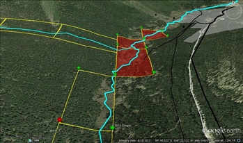
GE can be effective when combining data from the BLM's LR2000, General Land Office records, USGS of registered mines, the PLSS survey system, water flow in rivers and so on. There are many wonderful overlays online that can help you identify an area that might be good for prospecting. You can easily install a land manger that will illustrate what lands are public and who is the authorized surface management agency (USFS or BLM)
GE can be effective when combining data from the BLM's LR2000, General Land Office records, USGS of registered mines, the PLSS survey system, water flow in rivers and so on. There are many wonderful overlays online that can help you identify an area that might be good for prospecting. You can easily install a land manger that will illustrate what lands are public and who is the authorized surface management agency (USFS or BLM)
HOW TO FIND GOLD CLAIMS
Using the BLM LR2000 database to research if a particular piece of land has gold claims, both active and closed.
Also a brief overview of using the PLSS mapping system in Google earth to plot the location of mineral claims.
http://www.blm.gov/lr2000
Using the BLM LR2000 database to research if a particular piece of land has gold claims, both active and closed.
Also a brief overview of using the PLSS mapping system in Google earth to plot the location of mineral claims.
http://www.blm.gov/lr2000
LOCATING AREAS TO PROSPECT
How to find areas to prospect for precious minerals.
http://apeoid.com/kmz-kml-padus
How to find areas to prospect for precious minerals.
http://apeoid.com/kmz-kml-padus
HOW TO FIND GOLD MINES
Using the Mineral Resource Data System (MRDS) hosted by the USGS.
Search for mines in an area and download the data in many formats, including Google earth.
http://mrdata.usgs.gov/mrds/find-mrds.php
Using the Mineral Resource Data System (MRDS) hosted by the USGS.
Search for mines in an area and download the data in many formats, including Google earth.
http://mrdata.usgs.gov/mrds/find-mrds.php
HOW TO FIND A WASH/ARROYO
Using Google Earth and USGS Topo maps to pinpoint washes, which
allow you to sample the contents of vast areas in just one location.
Using Google Earth and USGS Topo maps to pinpoint washes, which
allow you to sample the contents of vast areas in just one location.
